Agenda for a New Dallas Summit: Design Charrette Results

Last year, D Magazine published a special edition 13th issue dedicated to New Urbanism in Dallas and North Texas. In that issue, I (Patrick Kennedy) contributed two pieces as well as serving as guest editor. One of those articles was “Making Dallas a Place Where People Want to Live.” Despite the wordy title, it describes the kind of things the city has to do from a design, policy, and investment standpoint in order to boost livability for current and future residents, while not actively incentivizing people to flee for greener pastures outside the urban core.
One reason for the need is stabilizing city coffers by attracting new tax base. The other reason is for transportation and environmental reasons. If you want to solve congestion, you need to encourage short trips rather than long trips; long commutes lead to car trips and CO2 emissions. Therefore, we want to encourage people to live close to where they work and work close to where they live. To make that happen, Dallas has to provide the kinds of places and neighborhoods that people want to be near. Attract people and you’ll attract investment. Once you can attract investment, it is a lot easier to sail the ship than when there is no wind at your back.
That column then grew into a sold-out Summit (produced by the Coalition for a New Dallas and D) to educate Dallas’ leadership (and candidates) on the kinds of infrastructure improvements and investments the city needs to make in order to become a place built for residents rather than prioritizing visitors. Making it easier for people from Plano to drive to the urban core and park does not mean they will actually do it. In fact, Plano residents would probably prefer to have the same amenities closer to them. This is the fundamental dynamic Dallas seems to have forgotten over the last fifty plus years.
The “Agenda for a New Dallas Summit” focused on transportation infrastructure because that is the biggest capital investment the public sector makes that shapes the form and function of a city, in addition to the behavior of people and the market. It is the way people’s lives can get better and wealth is grown—or not.
Peter Park, the former director of planning at Milwaukee and Denver, who helped remove a highway during his stint in Milwaukee presented on how every time a highway was introduced to a city, the area got worse. Every time one was removed, the area, including the traffic, improved. Christof Spieler, director of planning at the Houston office of Huitt-Zollars and former board member at Houston Metro, discussed his experiences helping to overhaul the Houston bus system: why it was done and what it means to provide good public transit. To round it out, Lilly O’Brien-Kovari from LADOT spoke about Los Angeles’s Vision Zero program and providing safe streets in urban neighborhoods.
But the day didn’t stop there. That afternoon, D Magazine hosted a design charrette where the out-of-town speakers and several of the panelists joined local stakeholders and designers to help resolve issues related to I-30, I-345, and D-2. The goal was to get some fresh eyes on these potentially major infrastructural projects and help understand how to better interconnect downtown, Deep Ellum, Fair Park, and The Cedars. (We were also joined by several graduate students from SMU’s Sustainable Design program because we thought it would be a fun learning experience for them; you can’t just play the short-game of changing hearts and minds, but also the long-game of grooming the next generation of planners and designers.)
To kick-off the event, Ian Lockwood from Florida presented on the kinds of street networks that foster healthy, sustainable cities that create wealth and opportunity. Spoil alert: it isn’t the hierarchical, dendritic networks of the limited access highways of conventional traffic engineering. Ian closed his remarks specifically about the concept of “confluences.” Confluences are breakdowns in the reticulated or highly interconnected grid. You will recognize them by the places that look like spaghetti on the map, are incredibly confusing and unintuitive to navigate, and always unsafe and undesirable for pedestrians. These areas were almost invariably built in the 1960’s or 1970’s and always yield disinvestment. Hostile to people, hostile to investment.

An example of a confluence.
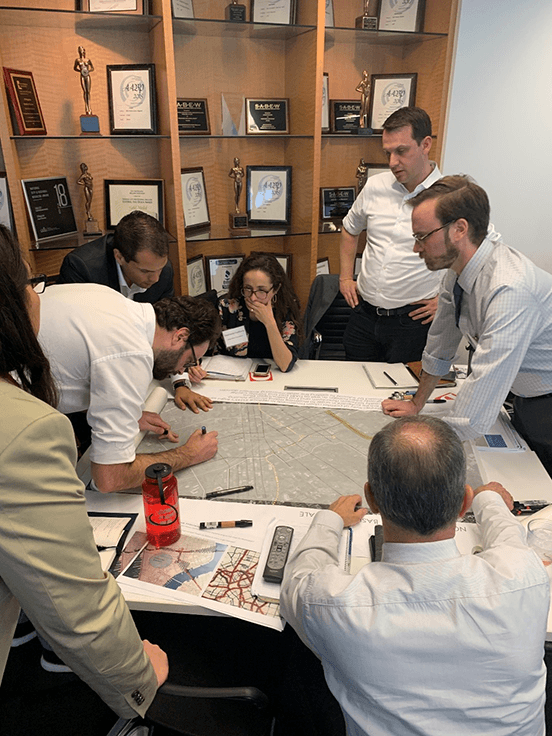
We then broke up all the participants into four teams at four tables each with a unique map of Dallas. If you think about the I-45, I-345, and I-30 highways as a N-S and E-W running plus-sign dividing up the four quadrants of Downtown, Deep Ellum, Fair Park/South Dallas, and The Cedars, the teams were assigned to either the Northern, Southern, Eastern, or Western “divides.” They were then asked to figure out how to improve connectivity, resolve the confluences that they could identify, and design for new opportunities for great urban streets, public places, and mixed-use development where currently there might only be pavement, parking, or otherwise wasted space.

The groups getting to work around their tables.
Along with their maps, sharpies, and markers, each group was provided with background information from the , traffic counts on various corridors, proposed plans around the study areas, and other potentially useful background information. The goal was to throw as much at the wall, see what sticks, what they can all agree on, and then attempt to refine into something they would later present to an open happy hour to various supporters and interested parties.
The “Northern” team assessing how to reconcile I-345 and the potential D-2 subway line.

Cary Moon, the runner-up in the most recent Seattle Mayoral election and lead advocate for the recently demolished Alaskan Way Viaduct elevated highway, joined the “Western” team to help resolve all of very big and disconnected infrastructure of I-30, the Convention Center, and various rail lines including high speed rail into a more cohesive, livable, and vibrant urban neighborhood. She would later speak to the happy hour about her lessons of advocacy in Seattle.

Selfishly, this exercise was also a chance to bring together some of the people locally and nationally that I have learned the most from, like Eurico Francisco and Peter Park shown here. They worked on the eastern quadrant where Fair Park feels like it’s a million miles from Deep Ellum when it’s actually only about one-half mile away. They quickly identified that the primary problem (besides the glaring one of I-30) was that there were three good grids aligned in different directions that where they would converge remained unresolved as a confluence (particularly the one shown above at Canton and Exposition.
The following images are what was presented by each team at the viewing happy hour, which was open to attendees of the Summit that morning.

The Northern team, which included designers Dustin Bullard, Ben Reavis, and Executive Director of the Deep Ellum Foundation Stephanie Hudiburg (plus several area property owners), wanted to focus on replacing I-345 with an improved North-South street grid. They also decided to re-think D2 by throwing out the colors and using D2 to reorganize how the various lines connect throughout the system (of note: North is to the left on this image). They really liked the idea of maintaining the existing Green Line stations at Pearl-Arts District and Deep Ellum station while adding a new one on the new line under the East End Transfer Center and turning the entire area into a multi-modal hub.

The Western team, which included Christof Spieler from Houston and Cary Moon from Seattle among others, wanted to get I-45 dispersed onto surface streets by Al Lipscomb Way in order to improve E-W connections from The Cedars to South Dallas. They also focused on creating a potential multi-modal hub at the High Speed Rail station by extending the TRE over I-30 and diverting the DART red/blue lines in order to minimize distance between all of these various lines. There is a deck plaza over I-30 as the front yard for the multi-modal center. While they proposed improving all of the I-30 bridge crossings, they didn’t want to invest in an I-30 rebuild and suggested to instead save the money with an eye to ultimately removing I-30 sometime in the future.
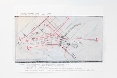
The Eastern team—which included Park and Francisco as mentioned above—really focused on resolving the three varying grid orientations of Downtown/Deep Ellum Elm-Main-Commerce, East Dallas, and Fair Park’s Exposition-1st-2nd Avenues. They eventually decided to scale I-30 down to a broad boulevard that terminates at a Robert B. Cullum Boulevard that would then bend into downtown, providing a Fair Park-Downtown connection. They provide improved access and a new front door for Baylor Hospital by making an improved connection from Haskell Avenue by Fair Park to Washington Ave. Of the three grids, they chose to resolve the disorder into something more rational and developable by prioritizing the connections between Downtown/Deep Ellum and Expo Park/Fair Park as they’re both more about commercial and entertainment uses. In doing so, they preserved the residential grid of East Dallas as secondary in order to maintain that area as more residential in focus, but with good connections back to the commercial and entertainment focused areas.
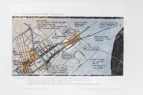
The final group was the Southern team, led by local planner and developer Paris Rutherford, which needed to resolve the confluence of I-45, US-175, Cesar Chavez Boulevard, and Good Latimer Expressway (and to take the express out of Expressway). They felt it important to scale I-45 down as far south as possible—encourage interstate traffic to use I-20 and I-635 to circumnavigate the city and get the truck traffic out of where people would be living, working, and playing. One way to do this could be to provide bus only express lanes on what is currently I-45 that could in essence ‘vacuum’ up the east-west bus routes on Loop 12 and Simpson Stuart providing a rapid trip into downtown. As part of the boulevard-ing of these corridors, the team felt it important to provide a signature gateway element in order to announce the transition from car space to people space. It also helps resolve the confluence as a new public square with redevelopment opportunities surrounding, which would help revitalize the area around the historic Forest Theater.
We’re just getting started.
While this was a fun and interesting exercise intended to provide some fresh thinking and new ideas to old problems, this effort will serve as the kick-off of an in-depth economic development and urban design plan for the area in conjunction with the city’s Strategic Mobility Plan. The various ‘big ideas’ will be reviewed for practicality, feasibility, and possibility. Most importantly, the ideas will be reviewed through the cost-benefit lens of: 1) how to get them built and 2) will they help deliver needed economic development, housing options, and improved quality of life for the city. Regardless, we know that if Dallas leads on these efforts, we will build a city for the future.


